Geography of Armenia
RELIEF
Geography of Armenia: Armenia occupies the territory of Armenian upland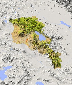 s; consequently, its relief is basically mountainous and consists of numerous high mountain ridges (about 47 % of the territory), intermountain hollows, extinct volcanic mountains, plateau and plains. The features of nature are reflected in the Armenian legend: when the God created the earth it turned out too stony. The God did not like it. So He gathered all stones in one pile and asked the people created by Him: who wants to live there? All refused but Armenians who are still proud of it.90% of the territory of Armenia is located at height from 1,000 m above the sea level and higher. The highest point of Armenia is the top of Mount Aragats (4,090); the lowest is in the gorge of the river Debed (380).From north and east Armenia is framed by the ridges of the Small Caucasus. In the central part of republic are sit
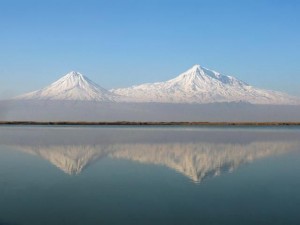 uated the Aragts, Pambak, Geghama, Vardenis and Zangezur ridges criss-crossed by a network of valleys and deep gorges. The country’s southwest is occupied by rather flat Ararat Valley (average height – 850-1000 m) in which the majority of large settlements of the country is concentrated. The country’s southeast is beautiful with magnificent mountain landscapes. Mountain valleys and plateaus, narrow gorges, rapid rivers, small lakes and the picturesque villages which are literally stuck to the hillsides are the main attractions there. It is worth mentioning that the country’s territory is framed by over 3,000 km of mountain ridges.
The Highest Mountains
- Aragats – 4,090 metres above the sea level (the highest point)
- Kaputdzhukh – 3,906 m above the sea level
- Adzhaak – 3,598 m above the sea level
- Spitakasar – 3,555 m above the sea level
- Vardenis – 3,522 m above the sea level
LAKES
Armenia has one large fresh water lake – Lake Sevan and dozens of smaller shallow ones. Lake Sevan is located 1,900 m above the sea level in the mountain hollow in the country’s east. Its area is 1,240 sq km, depth – 83 m. The lake is fed by precipitations as well as 28 rivers flowing into it: the outflowing is the river Razdan (the Araks inflow).Lake Sevan is surrounded by mountain ridges: from the northwest – the Pambak, from the northeast –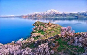 the Sevan and Areguni, from the west and the south – Geghama and Vardenis ridges. Two headland jutting out into the lake – Artanish (from the east) and Noratus (from the west) divide Lake Sevan in two parts: the Small and the Big Sevan. The Small Sevan differs in bigger depth and indented shoreline. The Big Sevan has even bottom, its shores are not deeply indented. The lake is extraordinary picturesque. Its turquoise-azure waters, pure curative air and the beauty of surroundings attract big numbers of holiday makers and travelers. The lake is bordered with a wall of artificial woods (pine trees, broad-leaved species and sea-buckthorns).The Sevan basin hosts the national park “Sevan” with four reserves and ten sanctuaries. Many rare species of waterfowl live there. The lake itself is a home for trout, pollans, and cancers.
The Main Lakes in Armenia
- Lake Sevan –1,200 sq km.
- Lake Arpi – 22 sq km.
- Lake Akna – 0.53 sq km.
- Lake Sev – 2.0 sq km.
RIVERS
Armenia is not rich in water resources despite having quite a network of rivers – they are rather small. All in all there are more than three hundred rivers of 10 km and longer. Some of them cut deep gorges and canyons in steep stony rocks. The majority of rivers in Armenia are the i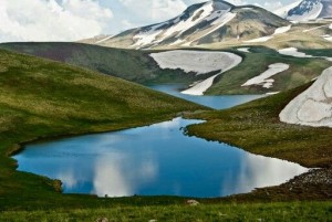 nflows of the river Araks – one of the largest rivers in the Caucasus flowing across entire Georgia and running into the river Kura on the territory of Azerbaijan. The big inflows of Araks on the territory of Armenia are the Akhuryan, the Kasagh, the Razdan, the Arpa and the Vorotan. The rivers Debed, Agstev and Akhum are the right inflows of the Kura running into the Caspian Sea. Some Armenian rivers belong to Lake Sevan basin. The rivers are fed with thawed, rain and subsoil waters. In spring the rivers become rapid and deep. And in the middle of summer the rivers get shallow and in the autumn their levels will rise at the expense of rain water.
The Longest Rivers:
- Araks – on the territory of Armenia – 158 km (total length – 1,072 km)
- Akhuryan – 186 km
- Vorotan – on the territory of Armenia – 119 km (total length – 179 km)
- Debed – on the territory of Armenia – 152 km (total length – 178 km)
- Razdan – 141 km
- Agstev – on the territory of Armenia – 99 km (total length – 133 km)

